Thursday, February 25, 2010

Road photos updated


Dear Reader,

I've gone back through the blog and added some photos to the entries describing the driving parts of the trip. (Unfortunately I had forgotten to take the magic cord needed to download them from my camera to the laptop during the trip.)

And here is a final road photo (taken outside Merced) to make you smile.

Dr Mom

Tuesday, February 23, 2010

The Kids' Favorite Things

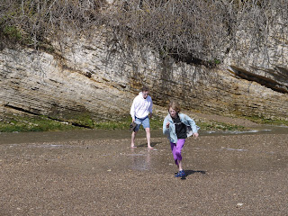
I interrogated the kids yesterday about their favorite parts of the trip. They both elected the Mosaic Canyon as their top pick, because they liked the scramble over the rocks and the sliding down the marble chutes. Their least favorite thing was the trucks driving on the beach at Pismo. Little Starlet also chose the beach at Montana de Oro as a top pick: She had enjoyed running in and out of the waves and getting stuck on the rocks.

Monday, February 22, 2010

More Death Valley Photographs - Badwater


Badwater was a source of despair for the first Europeans to reach Death Valley, '49ers who hoped to find a shortcut to the newly discovered Gold deposits in the Sierras. From a distance, the flats look like a freshwater lake; close-up, you can see the intense salinity - five times that of seawater - is causing salt to crystallize continuously beneath the unrelenting sun.


At 282-feet below sea-level, and with no exiting stream, there is nothing to stop the build-up of salt.

More Death Valley Photographs - Salt Creek

The hottest place we visited was not Badwater - that was just the lowest - but Salt Creek. The sun reflected over the salt-covered ground, just as it does off of snow, seeming to concentrate the already intense heat.


The creek itself is famous above all for its fish, called "pup fish", that gradually evolved to be able to withstand the salinity that became ever more intense as the desert grew dryer following the end of the last ice age. The water in the creek is more saline than seawater, yet the "freshwater" pup fish are thriving.

More Death Valley Photographs - Mosaic Canyon


Mosaic Canyon was our second, and final canyon hike. Further up the valley than Golden Canyon, it is just a little less desolate; and the flash-flood erosion here shows up as rock sculpture rather than simple destructiveness.


In the most violent floods, rocks carried in the torrent are smashed into drying mud, which then hardens to create the mosaic effect that gives the canyon its name.


A little higher up, the canyon broadens out into a wide, dry river-bed. Walking up it, you can see the volume of the floodwater that is concentrated at the canyon's mouth to create the rock sculpting and mosaic effects.


Eventually , as we climbed higher still, we found the canyon narrowing again until our way was blocked by fallen rocks, which we decided not to climb past to Little Starlet's evident scorn (click on the photo to see the facial expression in more detail).

More Death Valley Photographs - Golden Canyon

For our first hike, we headed into Golden Canyon, a hike that starts a couple of hundred feet below sea level. Above is the entrance to the canyon, close to the valley floor.


Here are the cliffs above the canyon, old lake-bed ripped up by earthquakes and then eroded by the violent flash floods.

Everywhere you look, just rocks and more rocks - nothing can grow given the aridity and the violent erosion when it finally does rain.


The only signs of life are the old miners' tunnels, horribly dangerous places into which only the foolhardy would venture.

A spectacular, extreme, intimidating place.

Sunday, February 21, 2010

Blown Home by the Wind

The wind continued to roar around the van all night. We didn't actually have a lot of trouble getting to sleep - Hubby told us all to think we were on a boat rocking on the waves, which seemed to help some of the family - but the van was cold in the morning from the drafts finding their way through cracks and crevices. That said, we weren't as cold as the two guys who had pitched tent in the site next door after we'd gone to bed. It was a dad and his son and, boy, did they look cold and miserable putting the tent away at 7:00am. It was not a night (or a location) for tent camping.

Everyone got splendidly clean in the campground showers. It was a revelation. Deep Thought had a bit of a problem with her towel and robe becoming soaked because Dad didn't warn her that she had put them on a seat for disabled people in the shower, and not a bench, but apart from that all went swimmingly (if you'll excuse the pun).

We set off promptly for our longest drive, 322 miles north to Merced and the McConnell State Recreation Area.

The kids watched "Guys and Dolls" on the portable DVD player while we drove along I-15 away from Calico, through Barstow - another depressed town going nowhere - and back to Mojave. Our route traversed a stretch of the Mojave Desert. I am glad that I didn't make more effort to find places for us to camp in the Mojave Desert, as we now feel like we've seen enough of it. Dry and flat with a lot of rocks. Impressive for its scale, and the contrast between the desert plain and the mountains, but not a place you'd much want to hang out. Or live. I guess some people choose to, though I'm not sure why... It seems clear from the state of most of the little towns that the young people leave and never return. One day these small towns will fall into the desert like the mining towns that preceded them. Some of them are half way there already. Quite a spooky thought, really.

We backtracked along our earlier route from Mojave through Tehachapi to Bakersfield. The landscape around Tehachapi is appealing, with rolling hills, more greenery, and a winding road that meets and greets the long distance railway in numerous places.

Bakersfield was as lovely as we remembered. This time there were no diversions. We stopped for lunch at the China Town Buffet off I-99 just at the edge of Bakersfield, and it turned out to be just what we needed. Imagine a bland single story building filled with 150 diners of all shapes, sizes, colors, and ages. About 85% of the men have facial hair - something we noticed was a lot more prevalent in the central valley - and everyone has at least three plates of food in front of them. It was a help yourself to everything buffet for $10 each, and we sure did. Little Starlet focused heavily on the meat options. Deep Thought consumed mostly appetizers, though she also tucked into some teriyaki chicken. Hubby ate ribs and shrimps, while I focused on brightly colored food skewered on sticks. It went down very well in all senses.

By the time we'd finished gorging ourselves, the rain had started to fall in Bakersfield. We decided to out run it. The kids armed themselves with "Nanny McPhee", and we set out along the ever-so-slightly-dull I-99.

Reaching Fresno, the rain was really coming down hard. Hubby put forward the crazy idea of abandoning our last night of camping and driving home. We decided to have a family conference in Merced, just short of the McConnell Recreation Area. Fortunately we were able to hold it in a Starbucks! Nectar of the Gods! (Our first sighting of a Starbucks for several days was in Bakersfield, which is how we knew that Bakersfield counted as civilization, and that we'd been experiencing the wilderness before that.)

The vote was taken and the decision made to return home. So that is where I am writing now, in our family room with a cup of tea.

Saturday, February 20, 2010

From Sand to Silver

Yesterday afternoon we went back to the sand dunes on Mesquite Flats, near Stovepipe Wells. It was a bit windy, which had obviously put people off because it was much quieter than the last time we’d visited. We walked out to the largest sand dune – according to the Park Service, over 700 feet high. Hubby and the kids walked across the top of the sand dune, a dramatic curve, while I remained on a peak below to take photos. Just like everything else in this area, the scale and colors were amazing. We spent about an hour and a half walking out and back, a distance of about two and a half miles. Going up and down the dunes, up and down, it was pretty good exercise for the old calf muscles.

Overnight it rained a bit. Not enough to make the campground significantly damp, but enough to wake up Deep Thought at 5:00am with the drops drumming on the roof of the cab. There was also a bit of additional dampness inside the tin can: Little Starlet peed in her bed for the second time on this trip. We couldn’t remedy the situation with her still asleep this time, but she is claiming that she had no recollection of us getting her up, fixing her bed, going to the toilet etc. I think the poor little thing was very tired again.

In the morning we saw another road runner scurrying over the sand in front of the RV. (This is the only photo we succeeded in taking of one.) They’re cute. We haven’t seen much other wildlife in Death Valley. A couple of little lizards, ravens at the campsite, hardly any insects (though we did see big black beetles at the sand dunes), an antelope ground squirrel, and we heard the coyotes yapping in the darkness.

We drove away from Death Valley along highway 190. At Death Valley Junction – a sad, derelict community steps away from becoming a ghost town – we turned south on highway 127.

This straight road took us through the bottom end of Death Valley and into Silurian Valley, back into the Mojave Desert. We didn’t see any Joshua trees in this part of Mojave. We did see some spectacular sand dunes in the distance at Dumont Dunes Natural Preserve. They looked even taller than the ones at Stovepipe Wells. We also passed many dry lakes.

The little town of Shoshone was in fairly good shape, with a health center, gas station, motel, café and several houses in good repair. At Baker, we turned west on interstate 15. Baker was most notable for having “the world’s largest thermometer” at the side of the road. It was a very easy drive from every perspective.

Calico Ghost Town is a few minutes from I-15. The campground at the Town is pleasantly laid out. We are in site A25, which has full hookups. This was essential as we ran out of water in the van this morning. Unfortunately it is incredibly windy. The van is rocking from side to side as the wind whistles through and up the canyons. It’s a whole new experience for us (and makes us very glad we aren’t in a tent). This will be the first evening that Hubby and I do not sit out by a campfire. It is just too darned cold – and we’re not even sure we’d be able to light a fire at all. Hubby tried parking the van to shield the fire pit, but there is simply too much wind for that strategy to work.

So here we sit. Deep Thought is writing something creative on one computer, I am blogging, Little Starlet is reading (and eating chocolate), and Hubby is in the RV shower! When he gets out, we’ll play a game.

Now to reflect on Calico Ghost Town. Calico was founded as a silver mining town in 1881. The boom years continued till the end of the 1890s when the price of silver fell dramatically and the population fell rapidly from its peak of twelve hundred (1887) to three hundred (1893) and down to only ten in 1951. During its active years, over $86 million of silver was extracted from the hills around here. The population also supported twenty-two saloons, a China Town (for washing and laundry), and a red light district. The town fell into decay until 1951 when Walter Knott, the founder of Knott’s Berry Farm near to Los Angele (a theme park precursor to Disneyland), decided to spend a bunch of money purchasing and “restoring” it. He donated the town to the County of Bernardino in 1966.

That’s the history lesson. The town today is basically a middle-grade tourist attraction. The entry fee is included in the camping charge, which was a good thing, or it might have offended Hubby’s Scottish sensibilities. The town consists of two main streets, with a short walk up to a school house, a mine, and a railway. The mine and the railway have separate charges.

The railway takes a short loop around the top of a hill, allowing a view of some derelict miners’ houses built into the rocks. (In its previous life the train hauled materials away from the mines.)

“Maggie’s Mine” is a genuine silver mine. Interestingly for those of us experienced in passing through mining exhibits in the UK, this one allows everyone to stand upright (and they didn’t insist on us wearing safety helmets, which they would have in the UK). It was fairly interesting to walk through the mine for a few minutes, though there was a minimum of interpretation – not even an arrow saying “Look, silver ore here”.

The kids wanted to pan for gold, but that exhibit was closed. We ate lunch in the Calico House Restaurant (burgers) and dessert in the Miners’ Café (ice cream). We also went into all the different shops, of which there were many, all selling the most bizarre things….like teddies with wings, cowboy statues, dream catchers labeled “Not an Indian Product”, a piggy bank dressed flamboyantly in feathers and sparkles, frilly toilet roll covers, scoop-your-own bath salts and, our absolutely favorite thing, a singing deer’s head which opened and closed its mouth and also told jokes. Honestly.

Deep Thought’s rating out of ten: five, because it was strange and it was a bit too touristy. She’d have liked it to look a bit more like a real ghost town. Little Starlet also rates it at five, because the stuff in the stores didn’t seem like it would ever have been in the town when people lived there. Hubby rates it more generously at six because all the effort at Disneyfication hadn’t completely hidden the mining town atmosphere. I’d rate it at seven, because I like the look of the rugged frontier town architecture (some of which was even real and not a 1950s pastiche).

Friday, February 19, 2010

Roadrunner Love

On the way to the Visitor Center for the wi-fi experience today, we saw Mr and Mrs Roadrunner doing their making babies thing. As Deep Thought said, And of course this is the only moment we haven't got the camera with us! It may surprise you to learn that roadrunners are not purple and greed. They are, in fact, dark brown with pale speckles, about the size of a chicken, with a nice plume of feathers on their heads. They really do that darting run too.

Salt and Pupfish

This morning I woke up with a cold. I can’t quite understand how that happened.

We went out at 9:00am to the Salt Creek Interpretive Trail about half an hour up the road towards Stovepipe Wells. It’s a half mile loop on a boardwalk, around and across a salt water creek and marsh area. It is reached by another exciting mile of gravel road over which Hubby always enjoys driving the RV. The salt creek was not a knock out attraction, but it engaged the kids for an hour or so. Essentially it is the only habitat of a tiny brown endangered fish called the Pupfish, which breeds at this time of the year and then pretty much dies in the summer. Only the few that make it into the permanent pools survive. At the moment there is a lot of water, and the prickleweed is flourishing. We saw lots of fish and Deep Thought took lots of photos of them. I'm sure we'll post some of them in due course.

At the end of the boardwalk there is a trail heading over the salt flats. We walked out on that for about ten minutes before it became clear that we were going to be roasted. The salt radiates a bright glare equal to any snowdrift and it definitely felt hotter than it had on either of our morning walks in the past couple of days (despite there being a light wind today). We came back, admired the fish some more, then headed down the road to the Harmony Borax Works.

Apparently borax “harvesting” has historically been the most valuable kind of mining in Death Valley, far surpassing gold or silver. Thousands of Chinese workers were brought to Death Valley in the nineteenth century to work in the extractive industry. The Harmony Borax Works is one of the best preserved sites. It has the wagons from a Twenty Mule Train. In each of these trains, two large product wagons and a 1200 gallon water wagon were literally pulled by teams of twenty mules the 165 miles to Mojave. We looked out from the Harmony Borax Works over the white plain where the workers toiled to extract the mineral. It was hot, bleak and depressing. Imagine being the people who came here from San Francisco to do that work. It must have been grim.

This afternoon we are going back to the sand dunes at Stovepipe Wells because the kids fancy running barefoot on the sand (watch out for scorpions!) and tomorrow we head south out of Death Valley, to Calico Ghost Town.

In the absence of showers for four days, the family is becoming increasiyngly fragrant, and you should see Little Starlet's feet - !

Across - and in Some Cases, into - the Salt Flats at Badwater (Thursday Feb 18 cont'd)

After lunch, we walked over to the Visitor Center to wrestle again with the “free wi-fi”. This time we had some success, as the blog testifies (see below for multiple entries posted all at once). The bandwidth was insufficient to allow Hubby to post the hundreds of photos that he wanted, so that has to wait for a better service. Watch this space.

I also asked in the Visitor Center for some advice on walks we could do. Our options are a bit limited by the fact that our vehicle is a 25 foot long RV. It turns out that Death Valley is really a driving park. We now have a better appreciation of why so many people are towing cars behind their motor homes. There are very few trails and those which exist tend to be of the out-and-back type (rather than a loop), which are reached by driving down dirt tracks. Many of these tracks are labeled for four wheel drive, high clearance vehicles only. They are too rough for bicycles. We’ve noticed numerous motorbikes on the roads; and these do seem the ideal way to get about the park.

Our options have also been limited by the closure of several minor roads due to mud. This might seem strange in a desert, but there has been some rain over the past few weeks resulting in muddy conditions which will, I guess, dry to difficult ruts if cars are allowed on the roads. So the affected roads remain closed. Alas, this puts the kybosh on the walk I had planned for Friday morning, along Titus Canyon. The ranger in the Visitor Center agreed that we hadn’t many choices. We’ve decided that we’ll opt for the easy trails at the Salt Creek Interpretive Center and perhaps the Harmony Borax Works tomorrow. As for today, we decided to spend the cool part of the afternoon at the salt flats in Badwater.

Badwater is a natural spring that oozes out dense salty water. It is the home of a rare tiny snail that lives nowhere else on earth. (We didn't see it.) The information signs explain that the water accumulated underground in the last ice age and that the salt leaches out of the rocks around it. The spring area is protected by a short boardwalk. Visitors are then permitted to walk out onto the salt flats (which cover a five mile area). We walked out as far as we could, which was to the edge of the area that was fairly dry, about half a mile. Little Starlet decided to be naughty and bumptious, and walked out further, sinking into the glutinous salty mud up to her ankles. (That’s one pair of socks destroyed and a pair of sneakers caked in stinky poop-colored mud.)

The salt flats are, well, very flat and dominate the floor of Death Valley. In the sunshine they shimmer with the promise of water – which of course turns out to be completely undrinkable. It must have been a great disappointment to those poor 49ers and pioneers, for whom we are developing a strong sense of sympathy. The salt crystals form a crust on top of the sandy mud, creating little mountainous peaks that echo the mountains ringing the valley. It’s a thing of great beauty on a small scale. The kids took a lot of photos…. We were also able to watch the sun set over Telegraph Peak, which has an elevation of 11,048 feet (in contrast to Badwater’s elevation of 282 feet below sea level, which makes it the lowest point in the USA). Nice.

We finished the day back at Furnace Creek with a slightly strange pasta sauce concoction for dinner - the joys of camping - and a round of our new board game, Snorta. Deep Thought set the fire up for mom and dad’s evening entertainment.

We can’t get over how quiet this campground is. Each evening, our campfire has been one of a small handful. Last night it seemed to be the only one. Deep Thought reckons that this might be because there aren’t many kids around, so the adults are able to go into their motor homes whenever they want. She also thinks that the high percentage of seniors in the campground might be a contributing factor, older people wanting to keep warmer and all that. It is true that we are seeing a lot of elderly campers, and we’ve met some of them doing their email in the shadow of the Visitor Center. Many seem to have fled the cold weather in Oregon and Washington state. We’ve even met a couple from Calgary in Canada. It also seems pretty common for these older folks to be spending months on the road, hopping from campground to campground in the warmer south. Given the size of many of the RVs – Enormous! Huge! Giant! Ridiculous! – it’s easy to believe that life could be sustained in them quite adequately for five or six months. Maybe that’ll be me ‘n’ Hubby one day.

Death Valley - Mosaic Canyon


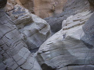
Still in Death Valley, connected to Internet over something with less bandwidth than damp string, but thought I'd post a picture. Here is the lower, narrow part of Mosaic Canyon; the rock has been scuplted smooth by the intense flash floods.

Thursday, February 18, 2010

Mosaic Canyon (Thurs. Feb 18)

Little Starlet had a bit of a problem in the night with her bladder. When we came in at 10:30pm, we discovered she was a bit damp and had made a puddle on the floor. I suspect she had dreamed that she had reached the toilet. Hubby and I undressed her, dried her, re-dressed her, and turned over her duvet without waking her up. I think the poor lamb was a bit exhausted. (Deep Thought didn't wake up either, and she is usually a light sleeper; but we weren't holding her legs up by the ankles.) Anyway, no real harm done, and Little Starlet took it all in her stride. We dried everything out in the sun this morning while we were out at Mosaic Canyon.

This canyon is just west of Stovepipe Wells. To get there, you drive down a two mile long gravel road: Shades of the drive into Butte Lake campground last year, but not so intense. Everything rattled a lot, and we had to stop twice to stop things sliding off Deep Thought's bunk, but we survived. Hubby just loves those drives.

Mosaic Canyon is so called because the walls are, at least at first, made of conglomerate with large chunks of marble. It's very appealing, with a sort of tortoise shell pattern. As the canyon continues, it gets single-file narrow, and you have to clamber up smooth marble shutes (which you later have to slide down on your bottom, much to the entertainment of the kids). The walls are very smooth indeed. Deep Thought wondered why all the marble had not been extracted, but we guessed that it had too many gractures in it to be usable.

After the narrows, the canyon opens out into a valley, quite broad, and easy to see how the water rushes down it in a flash flood. In fact it was quite plain to see how much force the water would acquire as it moves from the plain to the narrow canyon. It must be quite a torrent; and thus the smoothness of the marble canyon walls.

The walk ends at a dry fall which I had no intention of clambering down, though apparently if you do the canyon continues for another half a mile. All told, it was a three mile round trip, not as challenging as yesterday, but pleasant and quite different from Golden Canyon. Hubby took about 200 photos of rocks.

This afternoon we are heading over to Badwater, which is the lowest place in the USA (about 282 feet below sea level).

All Quiet in Death Valley (Weds. February 17)

Furnace Creek is a very quiet campground. Hardly anyone seems to sit out in the evening. By the time we went to bed at 10:30pm, we seemed to be the only people still outside their RVs. There are also a few people in tents – they seem to go to bed earlier. I guess that people are trying to get an early start, which is highly recommended if you are planning to go for a walk.

This morning we were at the Golden Canyon trail head by 9:00am. Our plan was to walk the Golden Canyon’s interpretive trail, then continue on either the Zabrieski Point spur, or make the walk into a loop by taking the Gower Gulch trail. In the event, 500 feet of climbing persuaded the kids that there was no way they wanted to climb a further 400 feet to Zabrieski Point so we did the loop. It really was pretty steep. The walk was about four miles. I felt very virtuous!

Anyway, Hubby’s photos will no doubt show the glories of the landscape, so I’ll just make a few comments. When we started down the trail it was pleasant and fairly cool. By the time we arrived back at the RV three hours later, we were all very hot. It’s probably in the mid to high 70sF by noon, though the hottest part of the day is actually 2:00pm to 3:00pm. The walk through the Golden Canyon was impressive – that’s pretty much what we say every five minutes: “Wow, look at that rock formation, isn’t it impressive?” – and quite varied. Much of the canyon is mudstone, but there is also a magnificent red cliff – “Red Cathedral” - which looks like draperies and buttresses made of delicately carved stone.

One of the things that has really struck us about Death Valley is how colorful it is. Brought up on Westerns and Laurence of Arabia, we tend to think of desert as yellow sand, but Death Valley is far from that archetype. Every set of cliffs is awash with a wide palette of colors: yellows, greens, pinks, reds, purples, black, cream, even a little blue. The variety is astonishing. Little Starlet is in rock collector’s heaven, though it makes the walking slow (and, of course, we tell her that she can’t keep more than one or two little rocks from the many finds she makes).

After we walked through the Golden Canyon itself, we climbed up to the sheer face of Manly Peak (named after a man called Mr Manly, not a statement of how butch you need to be to get there) – which reminded Deep Thought of Half Dome in Yosemite - and then turned left into the winding, damp bed of the gulch. This part of the walk was rough, rocky and winding. Little Starlet lost the will to live after about an hour, but Deep Thought insisted that the end was “just around the corner” and generally went all girl scoutish on us to keep our spirits up. It made a change from the waves of teenage hormones that have been somewhat evident on this trip…. We passed the entrances to several abandoned borax mines created, it seems, by lone miners mostly in the 19th century. Little Starlet and Hubby went to stand inside one of the most cavern-like, but carefully did not move further than the entrance as we have heard all about the hazardous nature of these mines (hazards which can sometimes include abandoned and, by now, unstable dynamite).

The gulch took us through what is termed the “badlands”. Arid and bleak, very little clings to life here, just the occasional desert holly. Deep Thought saw a lizard on the trail, the first we have seen since arriving. Putting ourselves in the shoes of the pioneers, we felt that if we’d ended up in a place like this, we’d have simply given up hope of survival. Those old timers sure were tough.

At lunchtime, back at Furnace Creek, we spotted a kangaroo rat. This is one of the few mammals that lives around here; the coyote is at the top of the food chain. Kangaroo rats are notable for having nostrils that enable them to reabsorb the moisture that they would otherwise breathe out. Little Starlet said it was like “a big chipmunk with a super curly tail”, which is a pretty good description.

Later in the afternoon we headed out to the sand dunes close to Stovepipe Wells. We left it a little late, so we only had half an hour of the best light. (Hubby was frustrated to be thwarted in his plans to take a hundred photos of sand.) We decided to yomp across the sand towards the highest dune and it was great fun. Deep Thought and Little Starlet headed off in one direction while Hubby and I took another, but it was all very safe as we could see each other (and the many other people) all the time. The sand is super soft, but easy to walk across with a modicum of determination. The walk from the parking lot and back is about a mile and a half. Again, it’s another dramatic but really different landscape. This one fitted better with our preconceptions of what a desert should look like, but in fact sand dunes make up only a very small percentage of the overall acreage of Death Valley.

We were surprised to spot a couple of kids on sleds sliding down one of the steepest dunes. My kids thought they were crazy but they looked like they were having fun. Erosion is not an issue in the sand dunes area, it seems. Visitors are allowed to walk wherever they like, and the wind tidies up and makes it neat again. If time allows, we plan to revisit the dunes on Friday.

Mojave Desert to Furnace Creek (Tuesday Feb 16)

[Catching up with blog entries. The Furnace Creek Visitor Center offers free wi-fi for a few hours each day but we’ve had trouble accessing it.]

After being tempted to do email for a few minutes, we managed to set out around 10am. Our route took us up highway 14, then 395, onto highway 190 and into Death Valley. Though it was scheduled to take just over five hours, in the end we spent almost six and a half hours on the road. Hmm, could be something to do with nature presenting us with multiple photography opportunities. I’m sure you’ll see some of the results of that when Hubby gets a chance to blog.

It was a spectacular drive through a changing, but increasingly rugged, landscape. We were struck by the number of abandoned houses and other buildings – including something that looked like a barracks – along highway 14. Struck, but not surprised, as this was definitely one of those areas which made you wonder why anyone would live there. First stop at 10:30am was at the Red Cliffs Natural Preserve in the Red Rock Canyon State Park. As the name suggests, fabulous red cliffs.

After Red Rock, we drove through plains encircled by hills. Highway 14 is a long straight road running alongside the Sierra Nevada mountain range. It’s a curious contrast, the tall snowy mountains to the left, the dry plains to the left. I noticed on the map that the area is dotted with multiple named wells; and indeed the area is called “Indian Wells Valley”. How the Native American tribes ever survived out here is a mystery to us.

As 14 turns into 395, we were tickled by a roadside bill board with its enticing invitation to move: “Looking for a Few Good Doctors for the Uncrowded Eastern Sierra.” An inspired piece of marketing speak, but not, perhaps, quite an honest message. “Looking for Doctors who want to Live in the Desert, Miles from Anywhere” would be more like it.

As 395 trolls north, the landscape becomes more volcanic. This surprised us – we really hadn’t expected that at all, I guess because we now associate volcanoes with northern California, following our RV trip last summer - but there were ashes and cinders aplenty, including the Red Hill, a cinder cone that would have been worthy of Lassen.

We stopped to eat a quick sandwich lunch on the side of the road at Owen’s Dry Lake. This is a shimmering white plain on the horizon, ringed by the Sierra Nevada, Coso, and Inyo mountain ranges. Entering Death Valley National Park just after noon, we were impressed by the variety of colors all around, and particularly noticed the strong contrasts between the reds and blacks of the volcanic pumice.

At Father Crowley Point – named for a Roman Catholic priest who served the area for fifty or so years – we got out of the car for a short walk to the vista point overlooking Panamint Valley. In the distance, on the valley floor, you can see sand dunes and the remains of a lake – really nothing more than a damp sandy area. To the left and right the valley extends away into a misty haze, while the mountains loom in front. It should have taken us about 20 minutes to walk there and back, but we must have taken a hundred photos, so it took twice as long. On the way back to the RV, we met a family coming the other way which turned out to have children at the same school as our kids: The daughter recognized Deep Thought and greeted her by name. Honestly, you drive hundreds of miles….

Just before we headed to Furnace Creek, we made a final roadside stop at the Mesquite Flat. The thing that we really noticed there was the absolute quiet. Even Little Starlet was persuaded to stop talking long enough for us all to hear it.

We are now at the Furnace Creek campground, which is the “high gloss” facility in Death Valley. Hubby is slightly appalled by the lack of showers, but he’ll cope. (There’s actually a golf course a short distance away which seems madness to us, and a resort with palm trees. While we’re conserving water, they’re watering their super green lawns.) We spent an hour at the ranger program in the visitor center in the evening, listening to a talk about the 49ers and other pioneers who encountered, and frequently perished, in Death Valley. It was potentially quite interesting, but the presentation was dire and the kids got us to swear we wouldn’t make them go to another.

From Death Valley - Golden Canyon

Not much connectivity, but here's a photo from our walk on the first day at Golden Canyon. This view is from the top of the canyon; the valley floor salt flats are visible in the distance.


And one from the Mesquite Flats sand dunes, at the top end of the valley, shortly before sunset.

No connectivity :-(

We are at Furnace Creek in Death Valley. Alas we have almost no connectivity (writing this on Deep Thought's iPod, which is the only device we can get to work....).

Monday, February 15, 2010

Ribbit

There seems to be a large frog somewhere in the campground, giving us its all with the loud ribbits. Ah, the wonders of nature.

Mojave Desert


M choose a stopover RV campsite just because it was a good mid-point on the way to Death Valley. We went exploring, walked out the back gate and found ourselves in the Mojave, with Joshua trees, spiky plants and desert landscape all around.


Then M ventured -oh - about 8 feet into the desert, and immediately cut her leg on the spikes of this Joshua tree bud, above.

Happily, she found a way to survive, thanks to that old explorer's motto - never go into the wilderness without your Starbucks mug. Oh, and she wants it to be known that the mug contains tea, not latte; so that's alright, then.

Pismo Beach to Mojave Desert via Teletubbyland

We rose early and partook of the communal showers before anyone else was around. It was a blessing to see Little Starlet's feet change color under the water, to say nothing of the children's lovely fragrance... After getting away from Pismo at 9:30am, we made good progress north on highway 101, then east on highway 46 from Paso Robles, then highway 58. This was not the route we had imagined doing, but Hubby was not feeling up to the squiggley drive on the alternate route, so we opted for slightly longer but much straighter.

The landscape, ah, the landscape. It came at us in definite waves. First, east of Paso Robles, lots of vineyards. Large, wide fields of vines, punctuated now and again by small oil fields. (There seems to be a fair bit of oil extraction in this area.)

Following the vines came miles of soft, gentle rolling hills without any trees (though there also seemed to be very few animals, which would have been our guess for why it was treeless). At first it reminded us of Cumbria, but we soon came to realize that it most reminded us of Teletubbyland. Eh oh!

As we drove out of the hilly area into Antelope Valley, we entered a long patch of nothingness: Very flat, no animals or obvious agriculture, no towns, just the occasional house which would make the kids ask, "Why would anyone live here?" Eventually the nothingness gave way to nut orchards, mostly almonds we thought, which were just coming into bloom. In another week or so it would offer a very beautiful display.

More oilfields welcomed us into Bakersfield, and here we all found ourselves wondering why anyone would choose to live there. OK, we only saw part of the north of town, but it presented such an eloquent image of declining middle America that it would have had us emigrating back to the UK before agreeing to live there. Any place where the bill boards on the main highways are neglected is in a bad way. We stopped for lunch at Spencer's Diner, which was packed and hopping but offered only so-so food. Hubby did a spectacular piece of parking, diagonally across two spaces, without any assistance.

As we had made very speedy progress, I suggested a side trip to the Kern County Museum and Pioneer Town. I called their information line for hours etc, and we set off. After a twenty minute diversion we arrived - and it was shut for Presidents' Day. In the Bay Area, the attractions tend to open on the public holidays, including those that usually close on Mondays, so we were a bit surprised by that.

Since there was absolutely nowhere else to visit, we pushed on to our next campsite, Sierra Trails RV Park on Highway 14 just outside Mojave. There aren't many RV campgrounds in this area. I had read reviews of them all, and chose this one as the best of a bad bunch. In the event, we're quite happy with it. (Photo of our site, #19, at left.) You can hear the road noise, but the campground itself is very quiet with a mixture of visitors and long term residents. (And that presents another question: How do you end up living in an RV on a campground just outside Mojave, which is frankly in the middle of nowhere and has nothing much to offer except the desert?) For a mere $27.50 we have electricity and water hookups and access to a dump station if we wish. There isn't a fire pit, but Hubby has improvised with logs in the BBQ grill.

(Team G attaching the van to the hookups in photo at left.)

After arriving, we walked out behind the campground into the edge of the Mojave Desert. It is heavily populated with Joshua Trees, begging the question why you would need to go all the way to Joshua Tree National Park to see more?

Naturally Hubby took hundreds of photos, some of which he will post in due course.

Sunday, February 14, 2010

Sunset Day 2


The beach behind our campsite again. This time, we got there before the sun had actually set.

Mountain of Gold


The California Poppies that will cover the hillside in a few weeks (and that gives this beach its name) are just starting to appear, together with other Spring wildflowers.

Montana de Oro Beach Cave


K + C + Dad explore the cave, and get a little wet.

Montana de Oro Beach


Huge surf out in the Pacific - two-storey high waves were rolling in past the headland - reaches the beach.

The Beach


We tried to catch the sunset on the first night, but caught the dusk instead - Charlotte and Katherine playing on the beach as it gets dark.

The Campsite


Trees behind the parking spot where we have the RV (first night).

Beach Day at Montana de Oro

The day began cold and bright. The kids played a practical joke on us, pretending that Little Starlet had gone out to the toilet block and failed to return. In fact she was hidden on the over-cab bed behind Deep Thought. We fell for it totally.

We decided to head over to Montana de Oro (Mountain of Gold), which is about 45 minutes drive from Pismo Beach. All nice and easy, but when we got there the parking was murder. Turns out that a fun run was being held in the park today - the website said nothing about it - so we ended up parking along the side of the road in a space that was clearly too narrow for us; but Hubby did a fantastic job of squirreling us into the space. We had to get in and out of the van through the driver's door, but that was a small hardship.

We walked down to Skooner's Cove which has an attractive curve of coarse sandy beach, framed by sheer, crumbling cliffs. This was not a swimming beach, as the waves were very rough and there was clearly a rip tide at work; but the sea pooled in a small lagoon to one side, which allowed Little Starlet to run in and out of the waves and, eventually, to get wet from tip to toe. Of course, she made a couple of friends and was happy as larry for two hours. Deep Thought lay on a towel with her book, pretty much refusing to get up and certainly not to play with her sister (whose birthday was today).

While I assembled a picnic lunch back in the RV, the weather turned foggy and cold, so we took the hint and drove back to our campground. Hubby did a marvellous job negotiating the very narrow roads in the Montana park. He says that there's no need to find any more challenging drives for him, that will do.

Back at the Pismo Beach campground, we played around videoing ourselves for a project Deep Thought is doing for school (on the patriot hero Molly Pitcher - was she real or legend?); and then we took a walk down to the Oceana Dunes beach to see the sunset. We didn't manage to get run over by any trucks or ATVs on the beach, but we were still pretty offended by the way five miles of beautiful coast has been turned into a road.

Hubby and Deep Thought took many photos, which will be posted later.

Tomorrow, into the Central Valley.

Saturday, February 13, 2010

Bay to Breakers in less than four hours

We drove out of the Bay Area and got all the way to Gilroy before we had to stop for lunch. The Gilroy Outlets on Leavesley Road offer lots of options. We went for our favorite standby Fresh Choice. The kids are far too posh to go to McDonalds these days.

Full of salad and pasta, we headed south on Highway 101. Oh dear, what a dull drive. In this direction, 101 follows the Salinas Valley, along the route of the Salinas River. It is framed by large hills on both sides, but the valley itself is a flat, pretty uninteresting plain. I must admit that I dozed off somewhere south of Salinas. Hubby struggled to stay awake, while the gruesome twosome asked the classic “Are we nearly there yet?” at half hourly intervals.

One point of interest was the San Ando(?) Oil Field, which had a romantic collection of nodding oil derricks visible on the horizon, and there was even one working just a few feet from the roadside. This was also near to the major vineyard in the area, the Calivega(?)vineyard, which was so large Hubby thought they must have cornered the market in two dollar chuck; but that might be grossly unfair.

Other than that we couldn’t get tremendously excited: The road carefully bypasses all the little towns, so you get no sense of what it might be like to live there. In a few places there are shopping malls which look like the shopping malls anywhere in the Bay Area – same design, same architecture, same layout, same stores …. Very anonymous.

We arrived in Pismo Beach at 4:15pm - the whole journey took 3 hours and 45 minutes, give or take. It was a lovely sunny day, so the crowds were out in force. After one mistake, trying to book into the campground at North Beach, we were directed to our correct campground at Oceana. We have site 48, which has no hookups. I had paid for hookups, but the site where those are located is like an RV mobile home park, with all the vehicles just a few feet apart. We opted for the more spacious back loop without facilities. It was obvious the ranger thought we were mad as hatters.

Tempers were becoming a bit frayed in the tin can by this point so, after a quick pasta dinner, we walked down to the beach which is 0.1 miles out of the campground. Alas, it turns out that the campground backs onto the Oceana Recreational Vehicles Beach – in other words, cars and trucks are allowed to drive up and down it day and night. What a great shame. Why turn a lovely white beach into yet another road?

We saw some bats and two deer on the way to the beach. We also discovered a trail that heads over the sand dunes, so we plan to walk that in the morning, and then see if the ranger can suggest a non-vehicle beach nearby where we can take the RV for the afternoon. (We’re here for two nights so we get a full day at the coast.)

And now to drink tea, each salt and vinegar chips, and generally relax. Crackling fire, waves on the beach, hooting freight trains in the distance….